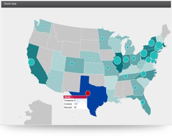
Solution Highlights
- Interactive Reports on Geographical Maps
- Batch Process to Generate Report Summary
- Drill Down From World View to Regional & Country View
The solution has been developed using amMaps (an interactive JavaScript library) to render the statistical and historical data quickly on the maps. It helps to analyze the marketing data of an organization by capturing the Lead statistics in a well defined view on the Map at different locations or geographies

Features
- Interactive Reports on Geographical Maps
- Drill down from World View to Regional & Country View
- Batch process to generate report summary details
- Tool tips & Color at specified locations
- Persisting user specific and previously used filter conditions
- Catching filter condition specific report summary details
Benefits
- Collects and analyzes the periodic and historical data to perform
market strategy for business development & forecasting - Depicts market statistical data on the World
- View of regional & country Maps using AmMap
